The trees were beginning to display their fall colors when we left Forks.

We made our way down Hwy 101, past more of the tall evergreens that continue to amaze us.

Down the coast we went, past Destruction Island with its now-decommissioned lighthouse. In researching this landmark, I learned that the fog signal on the 94-foot conical tower was placed in operation on November 1, 1891, and the beacon was activated in 1892. The tower is wrapped in a skin of iron to protect it from the elements, and it has survived the extremely harsh conditions off the Olympic Peninsula since that time.
The island got its name from Charles W. Barkley, captain of the British ship Imperial Eagle which visited the island in 1787. Sailors who went ashore traveled up a river and were massacred by hostile Indians. The captain then named the river Destruction River, and the name was eventually transferred to the nearby island. The river was later called by its Indian name, the Hoh, but the island retained its earlier moniker.
The island got its name from Charles W. Barkley, captain of the British ship Imperial Eagle which visited the island in 1787. Sailors who went ashore traveled up a river and were massacred by hostile Indians. The captain then named the river Destruction River, and the name was eventually transferred to the nearby island. The river was later called by its Indian name, the Hoh, but the island retained its earlier moniker.

A few miles down the coast, we stopped for a picnic lunch beside (or rather above) the sea. What a view! It just doesn’t get much better than this…smoked salmon with all the all the trimmings, and a selection of wonderful cheeses with a cold beer to wash it down.


After an otherwise uneventful trip down the coast, we set up camp at Grayland Beach State Park. Though the park is near the beach, we didn’t get to enjoy much beach walking. Our campground was inland of the dunes that protect the beach, and there is sand everywhere! Persistent showers kept us off the beach for the most part, except for a few excursions with the dogs.
The small town of Grayland is close to the larger Westport. We took a day trip there for lunch at Bennett’s Fish Shack. My clam chowder was excellent, and John enjoyed his fried oysters.

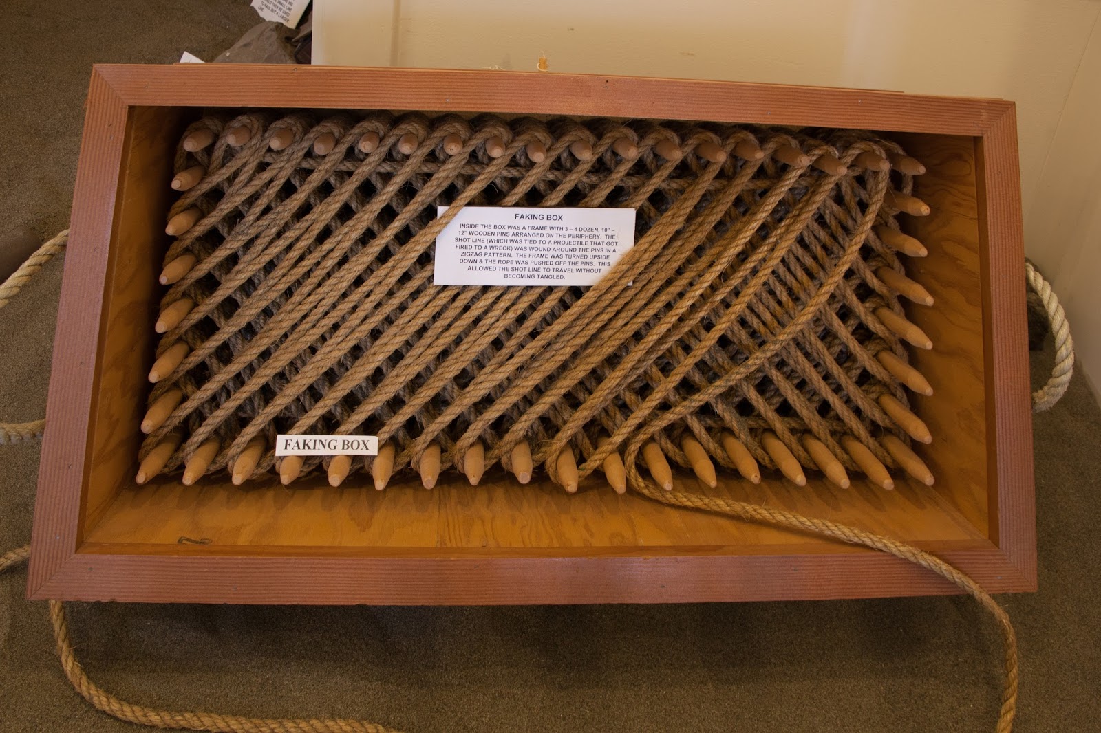
We then stopped in at Westport's Maritime Museum, which brings to life the history of the area, including shipwrecks off the coast and skeletons of some of the whales and other marine mammals that inhabit the coastal waters. I was especially intrigued by this clever "faking box" which sailors used to keep lines on board the ship from becoming tangled. When John and I were racing sailboats, tangled lines were always a hazard, so we can appreciate having a device to keep them organized.
But the showpiece of the museum is the First Order Fresnel Lens from the now decommissioned Cape Destruction Lighthouse, which we had seen earlier as we drove down the coast.


It is similar in design to the Fourth Order Fresnel Lens we saw at the Point Wilson Lighthouse at Fort Worden State Park in Port Townsend. The prisms that concentrate the light were manufactured in France in 1888 and shipped to Destruction Island, which is located about 50 miles north of Westport. It was put into service on December 31, 1891. In 1968 the Destruction Island Lighthouse was automated, and in 1995 the Fresnel Lens was replaced by a modern electronic optical device.
After being decommissioned, this lens was actually donated to the Westport Maritime Museum, and the community raised funds to build a new building to house it. In January of 1999, the new exhibit opened to the public. The lens is immense and magnificent. (You can see how large by looking at the people standing next to in in the first photo above.) When it was in use, its beam could be seen from 24 miles away and warned ships at sea of the dangers of rocks and shoals along the coast. What a treasure! It is a shame the lighthouse itself is closed to the public.
Westport also has a lighthouse, though it, too, has been decommissioned like most of the others along the Washington/Oregon coast. This one is unique, though, in that it is (now) inland instead of standing on the shore.

We were told that many years ago, in the 1930s if my memory is correct, a jetty was built in Westport to protect the port from erosion by the waves. One of the unintended consequences of the construction was that over the years the sand filled in behind the jetty. After the sand came trees and other vegetation. Now, the Westport Lighthouse is far from the beach and obscured by tall conifers. Years ago, this lighthouse was replaced by an automated beacon on the shore.
Our next stop was just across the Columbia River on the coast of Oregon. We traveled down the coast in steady rain, past a number of drive-up expresso locations and the Washington/Oregon version of a taco wagon, the fish and chips food truck.

We were also amazed at the number of fishermen in the rivers and bays in pursuit of salmon. (Although the rivers near Forks had been closed to salmon fishing, those farther down the coast were still open, and competition for the silver beauties was fierce.)

Our destination was Fort Stevens State Park in Warrenton, Oregon. It is another wonderful location to spend a few days. As we approached the bridge over the Columbia between Washington and Oregon, fog and mist hung on the hilltops on either side. We started across the bridge, watching the lines of barges moving up and down the river.


Then, just as we approached the top of the bridge…on a significant slope with RV and Tracker in tow, a flagman signaled us to stop. We were delayed several minutes by construction crews working on the bridge, then finally allowed to proceed. It was a heart-stopping few minutes. With both the RV and car in tow, we cannot back up, and starting from a dead stop on such a slope was an iffy proposition. However, John did a great job and we moved forward with no problems. High places aren't his favorites, though, and I'm not sure he looked down while we were at the apex.

Yep, you don't get trees like that around Austin. Maybe the Piney Woods but even then I'm not so sure. Great shots as usual.
ReplyDeleteThanks. Glad you enjoyed the photos. I guess Texas just does wide instead of tall, but 90 plus inches of rain up here sure makes a difference.
ReplyDelete